Unsplash/NASA
What if you could incorporate a globally-relevant skillset utilized by nearly every industry across the world into your Arts degree?
A new minor in Geographic Information Science (GIS) offered by the Department of Geography opens the door to career and research possibilities from working on natural disaster response to improving urban design and shaping the future of healthcare.
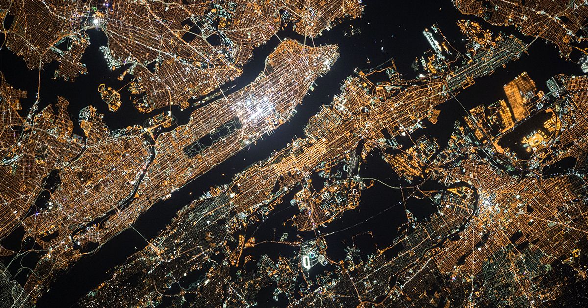
This might be your first time hearing of GIS, but you use it every single day. When you check to see how far away your takeout order is, read a news article with an infographic, or even browse the grocery store, you are using a system that has translated information onto a map. GIS is a combination of the software and the analytical knowledge necessary to do this. As we live in an increasingly data-driven world, it is becoming an essential skill.
The minor in GIS has been created to support students in developing these skills alongside other specialist subjects in Arts. “I was surprised at how useful and powerful GIS can be for humanities and social science-based projects,” says geography masters student Adriana DiSilvestro. “I had a preconception that it was only applicable to hard science-based work, which was ultimately not true at all.”
Courses in cartography, statistics and interpreting satellite data allow students to develop the necessary computational and coding skills, while elements of critical social theory and ethnography integrate more holistically with majors like Political Science and Economics.

“I was surprised at how useful and powerful GIS can be for humanities and social science-based projects.”
“There are no two ways about it—using GIS does involve learning some coding—but this shouldn’t put anyone off, as you just need to start with the basics,” says Dr. Brian Klinkenberg, a professor in the Department of Geography who has been teaching GIS for over 30 years. “The most important skill to have is a good internet searching philosophy! Most of the elements that require the use of code have already been written.”
DiSilvestro agrees. “I had no previous experience with anything even remotely like GIS, and was worried it would be too computer science-based for me to keep up with. I quickly figured out that while GIS applications have a bit of a learning curve as you get started, they’re actually really easy to use!”
Time and time again, Dr. Klinkenberg has seen students surprised by the sheer variety of ways they can use GIS. “People from other programs in the university have switched over to Geography, because they feel there’s so much they can achieve with GIS,” he says.
Among the projects that students have worked on include a recent undergraduate GIS project investigating whether Frodo had taken the most efficient route to Mordor in The Lord of the Rings. Another explored the potential for a high-speed rail connection to Whistler. Graduate students have also used the technology to combat elephant poaching, map the Irish diaspora in Vancouver and create a community bike-sharing program.
In 2021, DiSilvestro and two other graduate students published research on BC’s endangered caribou population using StoryMap, a GIS program that allows you to tell a visually driven story using images, data and maps. Their work was covered by CBC and is now informing future economic policy in the province.

“Every time you consult a website for locations of COVID cases, you’re using GIS. Every time you open Google Maps, you’re using GIS. Any time you use location services on your phone or in your car, you’re using GIS. It really is everywhere.”
Alumna Dr. Emily Acheson also used GIS to tell a BC story as part of her PhD; mapping the path of a rare fungal disease across Vancouver Island. Now, she says, COVID-19 has shown that we increasingly need medical geographers like her. “The pandemic has heightened the urgency for the use of tools like GIS in public health settings.”
We are depending more and more on GIS as we become more data-driven and data-hungry as a society. “I wish more people knew how vital GIS is for our everyday activities,” says Dr. Acheson. “Every time you consult a website for locations of COVID cases, you’re using GIS. Every time you open Google Maps, you’re using GIS. Any time you use location services on your phone or in your car, you’re using GIS. It really is everywhere.”

“I still see graduates from 10 to 20 years ago working in the field; for NGOs, transportation planning firms, the Center for Disease Control and First Nations communities.”
As we continue to experience more extreme weather events, GIS will also be on the front lines of the climate crisis — shaping policy, assessing flood damage or directing smokejumpers to fight the most critical wildfires.
To Dr. Klinkenberg, it’s a future-proof skillset. “I still see graduates from 10 to 20 years ago working in the field; for NGOs, transportation planning firms, the Center for Disease Control and First Nations communities. One even started up a remote sensing firm that has launched its own satellites! I’m glad to see the minor bringing more recognition to the unique expertise of GIS.”